Most of the trail is rated a 2-3. The climb out of the canyon can be difficult for a vehicle with open differentials, especially if it has low clearance. I would rate this climb at a 3-4, depending on recent conditions. When we went through we did have to strap a stock Jeep Liberty (the older body style) over one spot. We probably could have gotten him through, but it was tight and right next to a rock which could have caused body damage so we just opted for a strap.
Location
This is located in the San Rafael Swell in Central Utah. Basically, right next to the middle of nowhere (there is a freeway going through the area, so it isn't exactly IN the middle of nowhere).
Trailhead
This is located off of I-70, about 30 miles west of Green River.
The East side starts at Exit 131, Temple Mountain Road. From here you will take the road on the south side of the freeway, and follow it to the west. This road will be a dirt road and it runs parallel to I-70 in a westerly direction. From here there will be signs directing you to Swasey's cabin. Follow these signs as Swasey's Cabin is on the Eagle Canyon Road. If there isn't a sign for the cabin at an intersection, just head straight through. Once you make it to Swasey's Cabin, follow this road and it will take you through Eagle Canyon.
The West side starts at Exit 116 (Eagle Canyon View Area and Moore). Take the road that goes to the south of I-70 from the exit. This will turn into a dirt road almost immediately after crossing the freeway. The next turn can be a little easy to dismiss as it seems like it just heads back to the freeway. It will be a left turn about 1.2 miles measured from the cattle guard where the pavement ends. There is a tiny culvert that you will drive through to get underneath I-70.
Description
This is a fun trail and is definitely worth the trip. We drove for hours just to do this trail--and it was worth it.
This trail takes you through a canyon filled with tall cliffs and great views, and the views are great for the entire length of the road.
One of the highlights is Swasey's cabin. This is a fun little cabin built in 1921 and it is amazing to think that they lived in the rugged country. I can't imagine trying to live here back in the 1920's.
Along the canyon you will be met with a great view of Eagle Canyon Arch. This is easy to spot and you won't miss it. It is a "jug-handle" type arch where most of the arch is vertical. It is large and a great place to stop and enjoy the view.
One of the best parts of the road is the Eagle Canyon Bridges on I-70. You don't realize how high and how large these bridges are until you drive underneath them. It is truly a marvel to look at them from underneath. I haven't been on this road since I was a young kid (I'd guess 8-12 years old) and I was so impressed with the bridges that I have always wanted to come back.
As a side note: the trail is harder if you start from Exit 131. This requires you to go up the hardest climb. There is an alternate way out of the canyon according to TrailDamage.com. Just north of I-70 you can either climb out of the canyon to the left (south) or to the right (north). We went to the south to climb out of the canyon. This way has the hardest climb (the one that gave the stock Liberty some trouble) that we did, but it is also the way that takes you through the small, tight culvert under I-70 (another highlight I remember as a kid). I thoroughly enjoyed this climb and going under the culvert.
I do not know how difficult the road to the north (right) is, but TrailDamage rates the road as a 3. In addition, this way you have to exit/enter the freeway without a ramp so be careful!
All-in-all, this is one of my favorite trails in the area and I plan on coming back again!
Maps and GPS files coming soon!

Kids being kids...

Swasey's Cabin


We went 2 days after a huge storm. It was a little washed out...


Like I said, this arch is hard to miss...


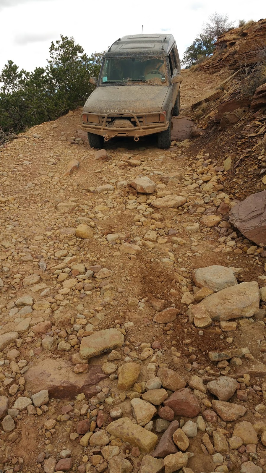
This was the hardest part. It really wasn't that technical, but there is a rock on the passenger side that you have to miss but there is an edge on the driver's side so you can't get too far away. And the further to the driver's side you get, the bigger the ledge gets as well, so you have to pick somewhere in between.


If I would have known Brent would take me this close to the rock--I would have made Tiona guide me instead. I told him FOUR inches, not four millimeters! Oh well, I didn't hit my corner panel, so all is good. Like my dad always said, "An inch is as good as a mile!"


See, I guided him much further away from body damage. Good thing too--he slid a little toward that rock!

This part was so much fun. Be careful, though, there was a HUGE hole (about 3 feet deep) on the passenger side (west side) in between the two culverts that was hidden in a puddle. I thought the puddle was 3 inches deep. I was wrong. I about peed my pants.


