Thursday, October 23, 2014

Gunnison Gorge Rim Road

Rating: 4. This is an easy 4, but there are a few spots that would make it difficult for a lower clearance stock SUV. 

Location: Just east of Delta, CO in the Gunnison Gorge National Conservation Area.

Trailhead: Starting from the more southern trailhead, it begins at Peach Valley Road east of Delta Co. We started where F road turns into Peach Valley Road. The coordinates are 38°43'35.9"N 107°56'01.1"W
(38.726627, -107.933627). Take Peach Valley Road to the east.

We ended near Austin, CO at the junction of H75 Rd and 2200 Rd. The road goes to the east from this intersection. The coordinates are 38°45'58.6"N 107°57'09.1"W (38.766283, -107.952519).
This is a fun little road in the Gunnison Gorge area. We actually did a few loops so we could be up on the rim as often as possible. There are great views of the Gunnison Gorge and a few views of Black Canyon National Park in the distance. The southern loop was the most difficult, giving this a rating of a 4. We started at Eagle Road and came down Bobcat road. Going in this direction gives you some fun climbs going up Eagle Road, many of which have 8-12 inch ledges and rocks. Some of these areas are dug out as well. I had to pick my line carefully since I have open differentials. On a few of the ledges and loose areas I spun out a few times and had to try a different line to make it up. It wasn't very technical, but some care is needed without lockers or high clearance. 

Coming down Bobcat Road was also a fun road. The hardest obstacle of the day was on Bobcat Road. This obstacle would be very difficult for a stock vehicle. My Cherokee with a lift and 31" tires had plenty of clearance. This obstacle isn't too difficult, but a little higher clearance and more aggressive tires are necessary. 

The rest of the trip was easier, but there were still areas that were loose and rocky. The best part was the view of the Gorge and the ride along the Gunnison River as it also had some great scenery. For me, one of the highlights is that it is near to my house!

This trail is a little more confusing as there are many roads in the area. As such, I will include some directions.

We started at F road and Peach Valley just east of Delta. We followed Peach Valley road to the east and then to the south for 9.5 miles. There is a left turn for Eagle Road. We followed this road to the rim and then followed the road north along the rim. While on the rim there is a road to the left that heads down and is called Wave Road. This road will take you back to Peach Valley Road or you can stay on the rim for a little longer and come down Bobcat Road (we did the latter). 

Once back to Peach Valley Road, we backtracked and followed it north for 3.7 miles and turned right onto Ute Road. This takes you back to the rim and you follow the rim north. You generally stay to the right so you can stay up on the rim. There are a few unmarked roads that go to the right and aren't well traveled. These aren't official roads so don't follow these. 

If you continue following the rim you will end up meeting the Gunnison River and will run into South River Road. Take South River Road until it ends at road H75. Turn left to get back to town. 

Here are the GPX and KML files of the trip.

If these don't work, here are the original GPX and KML files. There was about 20 minutes my GPS didn't record, so I had to manually repair the file. The repaired files work on my computer and GPS, but I can't guarantee they will work on other devices. 

It is easy to take a wrong turn, so if you aren't able to use my GPS files there is a map of the area from the BLM website. Luckily, you can't really get lost in this area because almost all the roads connect in to the Peach Valley Road (except for the north part which connects to the South River Road). 

 This is the nice, easy Peach Valley Road.

 This is shortly after turning off Peach Velly. Once you start going uphill it starts getting loose and rocky. 

 Nice view of the San Juan Mountains in the background.


 Black Canyon is just over my head. 

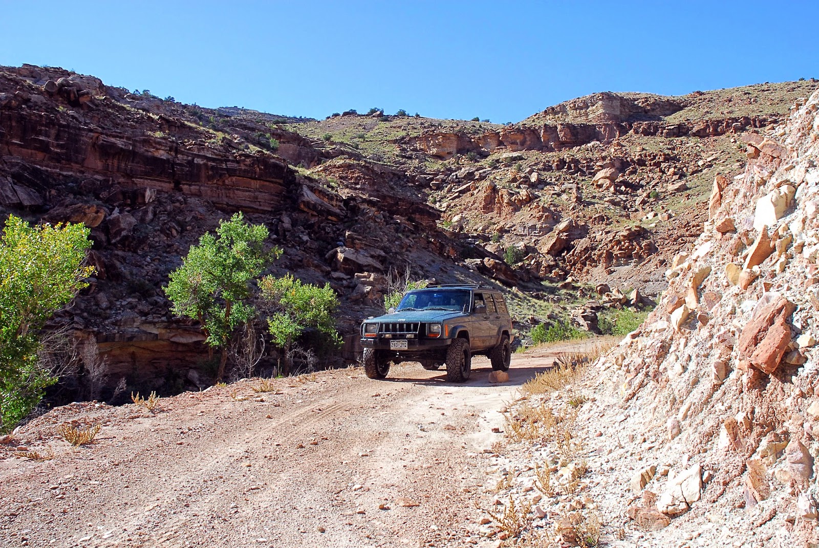
 This is typical for Eagle Road and the south loop. There are a lot of ledges, rocks, and loose areas that give it a rating of 4. 

 This is a typical view of Gunnison Gorge.

This is taken next to the Gunnison River on the South River Road. The river is where you can see the leaves changing colors in the background. 

Monday, October 20, 2014

Dry Mesa Jeep Road

Rating: 3. There are a few steep climbs and a few small ledges that would make it difficult for a small, low-clearance SUV without low-range.

Location: Just north of Delta, CO.

Trailhead: 11.9 miles north of Delta, CO from the Maverick gas station downtown. The GPS coordinates are: 38.784704, -108.246905. This is the trailhead for Escalante Canyon, and there are signs marking the turn. Take the Escalante Canyon road 6.2 miles, and there will be a turn to your left for the Dry Mesa Road and Escalante Rim Road. 0.6 miles after this turn there will be another turn.  The left is Escalante Rim Road and the right is the Dry Mesa Jeep Road.Coordinates for this turn are 38.712819, -108.261934.

The Dry Mesa Jeep Road parallels Escalante Canyon. The climb out of Escalante Canyon to the top of the mesa has some neat scenery and is moderately steep. There are no difficult obstacles, but with a number of ledges and rocks it makes it more difficult than the nearby Escalante Canyon or the Escalante Rim Roads. 

Once on top the scenery slowly changes from the desert landscape to the aspen and pine trees on the Uncompahgre Plateau. The aspen and pine forests are only present for the last few miles of the road. 

Toward the end of the road there is a turn-off to a dinosaur quarry. This short spur had many mud holes as it rained the day before. A few of them were fairly deep and I wouldn't recommend doing this spur alone if it is muddy you don't have good mud tires. There were a few times I was worried I was going to get stuck.

To get to the dinosaur quarry there is a 1/4 mile hike. The trail isn't well traveled and sometimes isn't well marked but it is still easily followed. There are signs when you get to the quarry that describe what dinosaurs were found, but the signs are in pretty bad shape. The quarry itself also isn't very exciting, it is just an area that has been dug out of the side of a hill. The view from the quarry, however, is spectacular.

One interesting fact about the quarry is that they found one of the biggest dinosaurs, a Supersaurus, which is among the biggest dinosaurs ever found.

Here are the GPX and KML files of the trip.

UPDATE Aug 31, 2015
My wife and I took a quick run on this road today. The stream crossings were a little deeper and more washed out, but the overall rating stays a 3. We did the trip in my Cherokee and the stock 4Runner TRD Pro.

There is a lot of open range in the area and some gates are closed and some are open. Remember to leave the gates the way you found them!

Here are some pictures from the trip today:


End of update


This is the view from the dinosaur quarry overlooking Escalante Canyon.

One of the many little ledges. This one was about 6-12 inches, depending on where you go up. A few of these ledges would have been difficult in our little Jeep Patriot because of clearance and the lack of low range.


The last few miles of the Dry Mesa Jeep Road actually take you into more of a forest, as seen in this picture and the next one.


This picture isn't actually on the Dry Mesa Jeep Road. At the end of the road I was planning on going back through Escalante Canyon. I took a wrong turn and ended up here. This was on road L37 which turns into the Sawmill Mesa Road. One of these days I will go on the rest of this road.

Wednesday, October 15, 2014

Granby Lakes

Rating: 3. There are many rocks on the road that make low-range necessary as well as a higher clearance stock SUV necessary. The last 1/4 mile after Big Battlement Lake will increase the rating to a 4 due to a few larger boulders that you have to climb over which would be difficult for most stock SUVs unless it has higher clearance.

Location: Grand Mesa, CO, near Island Lake.

Trailhead: The turn off from the pavement is 1.4 miles up the road from the Visitor Center for Grand Mesa. It is straight east from the Visitor Center across Island lake. Head north from the Visitor Center and the road will take you around the lake. The road is to the south of the pavement and there are signs for the Island Lake Campground.

The coordinates for the turn-off are 39°02'21.0"N 108°00'21.6"W (39.039161, -108.005987).

The Granby Lakes road starts 0.8 miles from the pavement and is to the right. It is less than a quarter mile from the Island Lake Campground. It is forest road 115.

This road is about 4 miles to Big Battlement Lake, which is where the rating of 3 ends. It is only about a quarter mile to Little Battlement Lake, and this section increases the rating to a 4 due to some large boulders. It took me about 2 hours to get to the end and about an hour to get back. If I didn't stop and take so many pictures, it would have been about 2-2.5 hours round trip.

The reason it is so slow is because most of the road is covered with 6-12 inch rocks that make it a rough, bouncy road. Some of the rocks are bigger and there are a few mild climbs. These rocks and climbs make higher clearance and low range necessary, giving it a rating of 3. There are also a few mud-holes that can make it more difficult if it has recently rained.

There aren't any technical spots except for the obstacle at the end. It is just a painfully slow road because of the bumps.

In the fall, however, the slow and bumpy road is worth it. When I looked on google maps, there are 12 Granby Reserveroirs and there are also Big and Little Battlement Lakes. You don't see all of them, but there are quite a few that make for some spectacular scenes with the fall colors.

Here are the KML and GPX files from the trip.


This is the area that has a rating of 4. 


This is coming back down the hardest area. The line I am taking is probably close to the easiest line. I could go maybe a foot to the driver's side, but there is a stream there with a lot of growth on the edges that forces you to go over the biggest rocks. The rocks just get bigger to the passenger side making that way more difficult. I didn't want to try the harder line because I was by myself and didn't want to risk getting stuck.

Here is a nice panoramic picture. This is Granby Reservoir number 12.


Old Grand Mesa Road

Rating: 1. This is a well maintained road that doesn't require high clearance. The washboards can get pretty bad on this road which might make it slow going.

Location: Grand Mesa, north of Cedaredge, CO.

Trailhead: 10.1 miles north of Cedaredge on highway 65 (measured from Main Street). 6.0 miles south of the Grand Mesa Visitor Center.

The coordinates are 39.004461, -107.942910 (39°00'16.1"N 107°56'34.5"W).

We started at the Old Grand Mesa Road, followed it in a north-east direction until it ended at forest road 121. We followed 121 west until we reached the visitor center.

The Old Grand Mesa Road is an easy dirt road that is a nice scenic drive off the pavement to get to many of the area's lakes and reservoirs. There are many dirt roads in the area that range from well maintained roads to those that offer more of a challenge. From my experience, most of the roads range from 1-3 in difficulty rating, but I have only explored a few of them.

The south end of the road starts in forests of aspen trees, which makes it a fun drive in the fall. As you increase in elevation, the forest changes to mainly pine trees with a few patches of aspen groves. There are many campgrounds and camping spots in the area as well as many places for fishing.

If you want something a little more challenging and not well traveled, take forest road 123 to road 122. The coordinates for the turn-off for 123 are 39°01'24.4"N 107°56'23.5"W (39.023452, -107.939850)  The coordinates for 122 are 39°01'43.9"N 107°56'51.6"W (39.028855, -107.947661). Forest road 122 is an enjoyable road with some bigger rocks and mud puddles. FR 122 is a short run, only about 4 miles long.

Here are the KML and GPX files from our trip.


Friday, September 19, 2014

Cinnamon Pass (Part of the Alpine Loop)

Difficulty Rating: 3. This is a clear 3 on the scale. You need 4-low and may need a little higher clearance than a small cross-over SUV. A stock SUV with low-range should be able to do this trail. This is a little easier than Engineer Pass, the other half of the Alpine Loop.

Location: Between Lake City and Ouray, CO.

Trailhead: The west side is 3.3 miles south of Ouray from the turn-off to Box Canyon Falls on the Million Dollar Highway (Highway 550). Coordinates are 37.988621, -107.649654 (37°59'19.0"N 107°38'58.8"W).

To be exact, the west side of Cinnamon Pass road doesn't start near pavement and this is actually the start of Engineer Pass. There is a connector that is well marked that will take you to Cinnamon Pass 7.0 miles after you leave pavement. You can also get to the west entrance of Cinnamon Pass from Silverton on the Animas Fork Road (County road 2) that starts at the Silverton Lakes Campground. When you get to the Ghost town of Animas Fork, there is a sign pointing the way to Cinnamon Pass. GPS coordinates of the start of Animas Fork Road are 37.818126, -107.650748 (37°49'05.2"N 107°39'02.7"W).

The east end starts near Lake City. The road is 2.2 miles south of 1st street in Lake City on Highway 149, and it goes to the right. You follow this paved road for 4.1 miles, where the pavement ends. It comes to a T in the road, and the Cinnamon Pass Road is to the right. Coordinates are 37.949241, -107.302314 (37°56'57.3"N 107°18'08.3"W).

Cinnamon Pass combined with Engineer Pass make up the Alpine Loop. The roads connect Lake City and Ouray, CO. If you are staying in Ouray, you could probably do the entire loop in one day, but it would make for a long day. It took me about 5.5 hours to complete Engineer Pass and it took me 5.5 hours to do Cinnamon Pass. Since Lake city is 2.5 hours from my house, we decided to do only half of the loop at a time.

I did Engineer Pass about 2 months ago in July and it was lush and green. When I did Cinnamon Pass a few days ago in mid September, the leaves were changing colors and the meadows were brown. The elevation is so high on the Alpine Loop that only short grasses, small wild flowers, and other similar ground cover can grow. They call this this growth the Alpine Tundra. These areas were brown and dying since it was so late in the year.

Cinnamon Pass was used by the Ute Indians before the white-man explored the area. In 1870's, the government felt that because the pass didn't cross the Continental Divide that mail could be delivered year-round across the pass. I'm not sure what they were thinking, especially since the pass reaches 12,800 ft in elevation. During the summer it is nice a cool on the pass, I can only imagine how much snow there would be in the winter.

The first road was constructed over the pass in 1877 and did well until the mining in the area declined. Now we have a fun jeep road thanks to that wagon road.

On the west side of Cinnamon Pass there is a ghost town called Animas Fork. Most of the buildings have been destroyed by the snow, but a few still remain. There is a group that maintains the buildings to help preserve the history. The highlight of Animas Fork is one house that has a big bay window, something I have never seen at any other mining ghost town.

Here are the GPX and KML files of the trip.

There were a lot of pretty leaves on the trip, I may
have gone a little overboard in taking pictures.


As I have said, we always find great spots for lunch.

The problem with lunch is that my daughter
wants to play and doesn't eat much.


She loves her chair we bring for lunch time!


This is American Basin, a small side trail I took
before I reached the top of Cinnamon Pass. It is 
only a few miles long, and the view is worth it.


This is the bay window at Animas Fork. You can go
inside the house and look around.

Here is a birds-eye view of Animas Fork.


This is the Alpine Tundra I talked about earlier. I have a 
picture of the same spot from my Engineer Pass trip. You can
 compare how green it was 2 months ago and now see how 
brown it is now. This field was full of purple flowers two 
months ago, now it is filled with brown, dead flowers.