Wednesday, December 23, 2015

Hurricaine Pass and California Pass

Rating: 2.5
This is a relatively easy trail, but there are a few climbs and a few small rocky areas that make 4-wheel drive necessary if you are in a stock vehicle. I only put my vehicle in low-range for the gearing but didn't need 4-wheel drive on the main road.

I did take a spur that increased the rating to a 3.5 due to a steep, loose climb.

Location
Near Silverton, CO

Trailhead
The trail starts right in Silverton, CO. If you follow Greene St (the main street) through Silverton and if you stay on the main paved road it will take you up toward California Pass and Hurricane Pass. Follow the signs to the Ski Area. Coordinates are 37.818210, -107.658357.

The trail ends at Animas Fork. Follow the directions to Animas Fork, once there if you stay to the left (west) you will end up on the road that takes you to Hurricane Pass and California Pass. Coordinates of this turn-off are 37.931924, -107.571134.

Description
Traildamage.com has this road listed as two separate roads, Hurricane Pass and California Gulch. Technically, these trails start once you are higher up the mountain. You follow Cement Creek for quite a way then you cross Hurricane Pass and then can cross California Pass to get to Animas Fork. This is an easy road without any significant challenge. There may be a few areas that 4-wheel drive is needed and low-range is nice due to some steep climbs, but a stock SUV should have no difficulties.

Near the top by Hurricane Pass we took a small spur that had a fun, loose climb that I would rate a little harder than a 3 but not quite a 4. I spun a few tires in my Cherokee (no lockers), but I wasn't worried about getting stuck. This spur ended with a great view over the road that you will be on after you cross Hurricane Pass.

The actual road for Hurricane Pass is short and connects Corckskrew Gulch (which I haven't done yet but it is on my list) with Poughkepsie Gulch and California Pass. The elevation of this pass is 12,730 ft.

Once you cross over Hurricane Pass you will be at the intersection of California Gulch and Poughkepsie Gulch. Taking California Gulch will take you over the pass and into Animas Fork. Taking Poughkepsie (a moderately difficult trail, one of the hardest in the San Juan Mountains) will come out near Ouray, CO.

This is where California Gulch starts and will take you over the pass and then down into Animas Fork. The road is similar in difficulty to Hurricane Pass but is a little less steep if memory serves me well.

California Pass connects Poughkepsie Gulch and Hurricane Pass to Animas Fork and the Alpine Loop (Cinammon Pass and Engineer Pass). The elevation of the pass is 12,960 ft.

Once you come out at Animas Fork you can either go to Cinammon Pass, Engineer Pass, or head downhill to Silverton.

Here is the KML track.


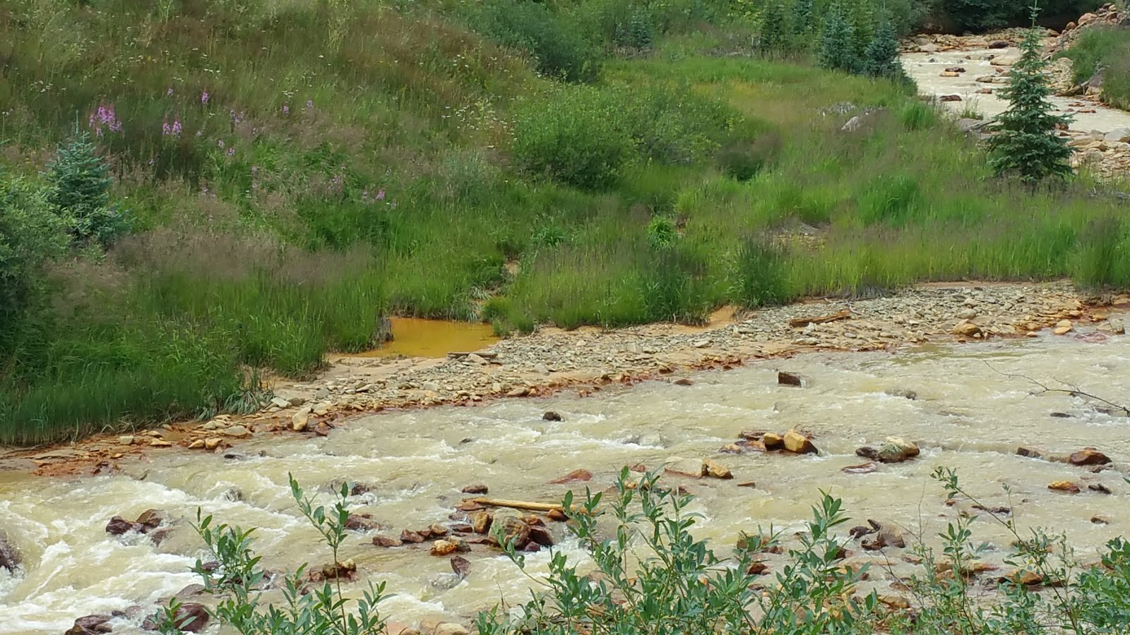
This is the site where the EPA caused a huge mining spill contaminating millions and millions of gallons of water. We went on this a week after the spill and the river downstream wasn't too contaminated but there was a lot of standing water that was opaque and yellow from the flooding when the spill ran downstream.


 This is the spur I took, sorry I don't have any pictures of the loose climb.

This picture is the view from the top of the spur.

From the top of the spur you can look down on the road that you will drive on after you cross Hurricane Pass. Hurricane Pass is just left off the picture. 


We always pick a great lunch spot with a fantastic view!


This is the hardest section of the road.


This is Lake Como, a beautiful little lake. I believe the road below is Poughkepsie Gulch.


Molly was really excited to see the sheep.

This is the spot where I fell in love with the San Juan Mountains when I was a kid. These rolling, green, alpine tundra areas stuck with me that when it was time to find a job I found one out here!


These are just above Animas Fork.

Animas Fork

Rating: 1-2
This is a well maintained road, but depending on when the last maintenance was performed and the recent weather, it may increase in rating to 2.

Location
Near Silverton, CO

Trailhead
This trail starts in Silverton, CO. Follow Greene St. through town and near the end in town there is a "Y" in the road. Go to the right at this intersection, which is Highway 2. Follow this road all the way to Animas Fork.

Description
This is an easy, well maintained road. 4-wheel drive is not necessary. There were a few rough spots, but with care a passenger car should be able to make it all the way to Animas Fork.

Animas Fork is a fun ghost town from the mining era in the late 1800's. In 1883 about 450 people lived in this town. They had a hotel, general store, saloon, and a post office. They even had their own newspaper for a few years. They had a 23-day blizzard in 1884 which dumped 25 feet of snow--they had to dig tunnels through the snow to get to the buildings!

One fun feature in this ghost town is that one of the houses was a 2 story cabin with a big bay window. Pretty impressive for a small, mining town!

There is a group that is actively preserving the cabins and structures. They have replaced a lot of the rotten wood to help keep the structures from collapsing.

Here is the KML track.

This is the cabin with the bay window.


This is the typical surface of the road and is passable by a passenger car.


Clear Lake

Rating: 3
This road initially starts easy and slowly worsens as you approach clear lake. Low-range is necessary due to some steeper climbs and some medium sized rocks. The last half mile of the climb is the hardest, and can be rated at a 3-3.5 depending on recent weather. The day we went it was raining making the last portion at least a 3.5.

Location
Near Silverton, CO.

Trailhead
This is an out and back road. The road starts 3.7 miles north (toward Ouray, CO) of Silverton on the Million Dollar Highway. The road goes to the west. There is a sign marking the turn-off saying "National Forest Access" and I think it also says "South Mineral Campground." GPS coordinates: 37.818218, -107.702502.

Description
This is a fun, short road that takes you to a fairly secluded mountain lake. The scenery is typical for the San Juan Mountains with many amazing vistas. The lake at the top is small, but nestled in a nice bowl surrounded by steep mountains. The road starts off as a well graded road and there are multiple campgrounds in the area.

The road is well maintained until you take the turn to the right that takes you to Clear Lake with a sign saying you need high clearance and 4-wheel drive. This turn-off is 3.7 miles from the pavement (37.805389, -107.762817). The road is fairly easy most of the way. The hardest section is the last climb before you get into the bowl. It isn't very difficult, but low range and a careful line are important. Any modified off-road vehicle will have no challenge on this road, but it may be a small challenge for a stock vehicle.

About 3/4 the way there is a cascading waterfall from the stream coming out of clear lake. This is located at one of the switchbacks and there is a small amount of room for you to park and enjoy the view.

On the way back down, we decided to follow the main road to the end.The road is was maintained until you passed the South Mineral Campground. After this the road became a little more rough, but not requiring 4-wheel drive. This road would be rated a 2 due to some rough areas making it less suitable for a car. The views are great up this road and it ends at a hiking trail.

Here is the KML track.


 This is one of my favorite pictures of the 4Runner. I love the orange water from the mine, the contrast between the orange and the green, and the way the 4Runner is going off the left of the picture with the road behind it. I think it looks like an advertisement for the 4Runner, "Toyota 4Runner TRD Pro, taking you places you never dreamed possible!"


 Once you get above the tree-line, the views are stunning!
 

This is the cascading waterfall. Molly was terrified sitting on this rock next to the edge. She was clinging to me frantically.  

 This is the hardest spot on the road. It isn't that bad, but it isn't quite as flat as it looks in the picture. I actually tried to take the hardest line so I could get a tire in the air. If you look closely at the next picture, my rear tire is about 1" off the ground--my locker worked like a charm. 


Molly loves her "Minnie 'brella"


 This picture and the next are on the road after South Mineral Campground (going straight on the dirt road instead of turning right to go up to Clear Lake). As you can see, it isn't difficult at all, but some areas can be a little rough. 


Tuesday, December 22, 2015

Mosquito Pass

Rating: 3
The trail has a few loose climbs that require 4-low and a little clearance. A few of the spurs can be more difficult. The spurs we took increase the rating to 4. There was a wash-out that made having a locker nice since I got a tire in the air.

Location
Near Leadville, CO

Trailhead
The eastern trailhead starts in the small town of Alma, CO. It is located off of Colorado Highway 9 between mile markers 68.9 (funny Colorado) and 70 and goes to the west. There is a sign pointing to Mosquito Gulch and the street sign is CR 12.  Coordinates are 39.270465, -106.047439.

The western side starts from Leadville, CO. You take 7th street to the east, this will turn into Rd 3 and will take you up to Mosquito Pass. Coordinates where the dirt road starts are 39.256243, -106.266122.

Description
This is the second highest mountain pass in Colorado with an unimproved road. The elevation of the pass is 13,185 ft. This was an old stagecoach pass.

This is a beautiful road that is a popular pass in Colorado. The scenery is breathtaking. There are a lot of spurs off the main trail going to various mines and can increase the rating a little. If you start from Alma, you go up the loose climbs instead of going down, but there is nothing very technical in either direction if it is dry.

We took a spur going to the South London Mine, which was a fun detour and a great place to eat lunch.

Sorry, no map or GPS files yet since I had to reset my phone and I'm not on the computer where I saved the files.


I just love Colorado mountains! 


Ouch. We had bought the 4-Runner less than 24 hours prior to this trip and only had about 100 miles on it. Oh-well, we bought it to take off road, right? I fixed it with some outdoor, heavy-duty velcro and it worked great. I think I need to get me a steel rear bumper since the overhang is huge and I've hit a few times...


I love this picture with my daughter just enjoying the view with Minnie Mouse. This was at the end of a short spur. 


This is where I ripped part of my bumper off going up. On the way back down I hit it again but not nearly as hard. This was on the short spur that isn't part of Mosquito Pass. 


This is also on the spur. This spot had a small washed-out area that made it a little fun. You can't see it in this picture, but my passenger side rear tire is about 6-8 inches off the ground. Going up this was fun since I got to test my locker out with a tire in the air! I didn't spin a tire at all. 


This is back on the main trail. This is a one of the typical loose climbs. A little clearance and 4-wheel drive was nice. 


 These next few pictures are on the spur to South London Mine. I'll write a separate post about it one of these days, but these are the pictures from the trip. 


 This is the last picture from the South London Mine spur. 

 At the pass! It was a respectable 13,185 ft.