Tuesday, March 29, 2016

Willow Springs Road

Rating: 3
This is an easy 3. There are a few ledges and a few areas that would be difficult for a small vehicle. 4-wheel drive is also required, especially since there are also a few sandy washes.

Location
This trail is an alternate way out of Arches National Park and connects to Highway 191 just north of Moab, UT.

Trailhead
The eastern side starts directly across the road from Balanced Rock in Arches National Park. GPS coordinates are 38.701743, -109.566903.

The western side stars off of Highway 191. There is a sign marking the turn-off that says Willow Springs Rd. The turn-off is 8.3 miles north of the main entrance to Arches National Park. GPS coordinates are 38.696681, -109.698697.

Description
This is a short way to get into or leave Arches National Park. Most of the road is relatively smooth and does not require 4-wheel drive. The area over the ridge has a few ledges and small climbs that are not difficult but require 4-wheel drive and a careful line if you do not have much clearance. The western portion near Highway 191 has a few sandy washes that also require 4-wheel drive to avoid getting bogged down in the sand.

The views are nice and there is an area with dinosaur tracks. The dinosaur tracks are fun because you can walk right along them and see the footprints left behind. You can even tell it was a three-toed dinosaur that left them. There is a place to pull off the road and an information sign that marks the location of the dinosaur tracks. The tracks are located on the south side of the road about 4.4 miles from the turn-off at Balanced Rock or 3.5 miles from the turn-ff from highway 191.

This trail only took us about 1 hour, including the time we spent looking at the dinosaur tracks.

GPS files and map coming soon!


Sunday, February 28, 2016

Crystal Creek and Bald Mountain Reservoir

Rating: 2-3
If you stay on the main roads, they are fairly well maintained and not much clearance was needed. We did a few side roads that increased the rating to a 3 due to the need for 4-wheel drive and a little higher clearance. I have been slow on updating the blog and I did this trail 5 months ago, so I may not remember everything perfectly. It seems that the last part (less than a mile or two) before you get to Bald Mountain Reservoir had some washed out areas that would increase the rating to a 3. Sorry, I didn't get any of the pictures of the washed out areas.  As you can see in the pictures, the surface of the road isn't bad. Rain might make things interesting, though...

Location: The West Elk Mountains in the Gunninson National Forest. The area is just east of Crawford, CO.

Trailhead
Sadly I lost my GPS route when I updated my phone. I thought I saved it but I guess I hadn't moved it out of the temporary files and I lost it. I am basing this off of memory and so a few of the details may not be 100% accurate.

I started about 12 miles sound of Crawford on CO Highway 92. The turn-off is clearly labeled with a sign that says "National Forest Access Crystal Creek." The road is to the east.  Coordinates are 38.548251, -107.541188.

The part I am not 100% clear on is where I came out. I am pretty sure it was at 38.463508, -107.451398. This is further south down Highway 92 (17.6 miles according to Google Maps). The reason I'm not sure is that Google Maps doesn't show the roads connecting to get to this point, but where the dirt road meets the highway looks like the same spot on street view. I can also see the road I believe I took on satellite view. I'm about 98% sure this is where I came out and so the roads should connect. This turn-off is 12.1 miles north on Highway 92 measured from the intersection with US 50.

Description
This wasn't our planned trip, I was actually going up Needle Rock Road from Crawford, but I missed the turn. Instead of turning around to go find it, I decided to drive down Highway 92 along the edge of the West Elk Mountains. I remembered that there were signs saying there was national forest access, so I drove until I saw one of the signs and took it.

Overall, this was an easy road. Most of it was well maintained, and for a while we saw passenger cars on the road as well.  The further up the mountain we went, the rougher it got. If you have a small SUV, you should be able to get most of the way up to Bald Mountain Reservoir. If memory serves me well, it was less than a mile that was washed out with some mud holes that made a little more clearance necessary.

We went during the fall, and the leaves were a great site. The real reason we went on the drive was to find some of the changing leaves. This trail didn't disappoint, as you will see below.

Bald Mountain Reservoir was a sad little reservoir. We went at the end of the year and it was almost empty. The views were still great and Molly had fun playing in the dried-up banks of the reservoir.

The road dead ends at the reservoir. Instead of going back the way we came, we decided to find another route down to the highway. This route took us along a ridge that overlooked the rest of the West Elk Mountains.  There are many short spurs leading off the road that goes to the ridge for spectacular views.

One of the spurs goes to a grave site of Benjamin C. Heilman who worked for the national forest. I can understand why he wanted to be buried there.  The coordinates for the site are 38.584522, -107.389489.

Directions
Once you turn onto the Crystal Creek turn-off, follow the main road for about 10 miles. There will be other turn-offs before this point, but just don't turn off the main road.

At about 10 miles you will reach a "Y" in the road. Stay to the left to get to Bald Mountain Reservoir. Continue following this road until you reach the reservoir. Google Maps says that there are other turn-offs from this road, but I believe all of them are closed except for some camp sites.

After you enjoy the tiny reservoir, return the same way you came. At the same "Y" above, you are going to go up the road you haven't taken (it will be a sharp left turn).  This road will take you along the ridge that gives you great views. You can follow this road all the way back to the Crystal Creek road if you wish

1 mile after you leave the "Y" the road will veer off to the right and there will be a campsite if you keep going straight. This is a great view if you want to check it out.

Continuing down the road, the grave site will be about 0.7 miles from the previous campsite. I highly recommend driving the 1/10th of a mile out of the way to see the view and the site.

If you don't want to go back to the Crystal Creek road, there is a left turn 3.8 miles from the grave site. We took this left turn. Follow this road for 5.9 miles and take another left turn. This road isn't listed on Google Maps, but you can see it on satellite view. You can follow this road back to the pavement. You will be going through a lot of private property, make sure you leave the gates as you found them.

Here is the KML and GPX of the track. These files were made using Google Maps and are not the actual recording of our trip. Therefore, there may be errors in the track.


 I did my good deed and cut some logs that had fallen over the road. Yes, I did it with a hand saw. Yes, I was sore the next day. There were 3 other logs I cut that aren't shown here.


This is the view from on top of the ridge.


What great hair. She sure loves pulling out her pig tails while in her car seat...


Such a funny girl...


The track was made using Google Maps. This is not the actual GPS recording from our route and as such may not be entirely accurate.

Wednesday, December 23, 2015

Hurricaine Pass and California Pass

Rating: 2.5
This is a relatively easy trail, but there are a few climbs and a few small rocky areas that make 4-wheel drive necessary if you are in a stock vehicle. I only put my vehicle in low-range for the gearing but didn't need 4-wheel drive on the main road.

I did take a spur that increased the rating to a 3.5 due to a steep, loose climb.

Location
Near Silverton, CO

Trailhead
The trail starts right in Silverton, CO. If you follow Greene St (the main street) through Silverton and if you stay on the main paved road it will take you up toward California Pass and Hurricane Pass. Follow the signs to the Ski Area. Coordinates are 37.818210, -107.658357.

The trail ends at Animas Fork. Follow the directions to Animas Fork, once there if you stay to the left (west) you will end up on the road that takes you to Hurricane Pass and California Pass. Coordinates of this turn-off are 37.931924, -107.571134.

Description
Traildamage.com has this road listed as two separate roads, Hurricane Pass and California Gulch. Technically, these trails start once you are higher up the mountain. You follow Cement Creek for quite a way then you cross Hurricane Pass and then can cross California Pass to get to Animas Fork. This is an easy road without any significant challenge. There may be a few areas that 4-wheel drive is needed and low-range is nice due to some steep climbs, but a stock SUV should have no difficulties.

Near the top by Hurricane Pass we took a small spur that had a fun, loose climb that I would rate a little harder than a 3 but not quite a 4. I spun a few tires in my Cherokee (no lockers), but I wasn't worried about getting stuck. This spur ended with a great view over the road that you will be on after you cross Hurricane Pass.

The actual road for Hurricane Pass is short and connects Corckskrew Gulch (which I haven't done yet but it is on my list) with Poughkepsie Gulch and California Pass. The elevation of this pass is 12,730 ft.

Once you cross over Hurricane Pass you will be at the intersection of California Gulch and Poughkepsie Gulch. Taking California Gulch will take you over the pass and into Animas Fork. Taking Poughkepsie (a moderately difficult trail, one of the hardest in the San Juan Mountains) will come out near Ouray, CO.

This is where California Gulch starts and will take you over the pass and then down into Animas Fork. The road is similar in difficulty to Hurricane Pass but is a little less steep if memory serves me well.

California Pass connects Poughkepsie Gulch and Hurricane Pass to Animas Fork and the Alpine Loop (Cinammon Pass and Engineer Pass). The elevation of the pass is 12,960 ft.

Once you come out at Animas Fork you can either go to Cinammon Pass, Engineer Pass, or head downhill to Silverton.

Here is the KML track.


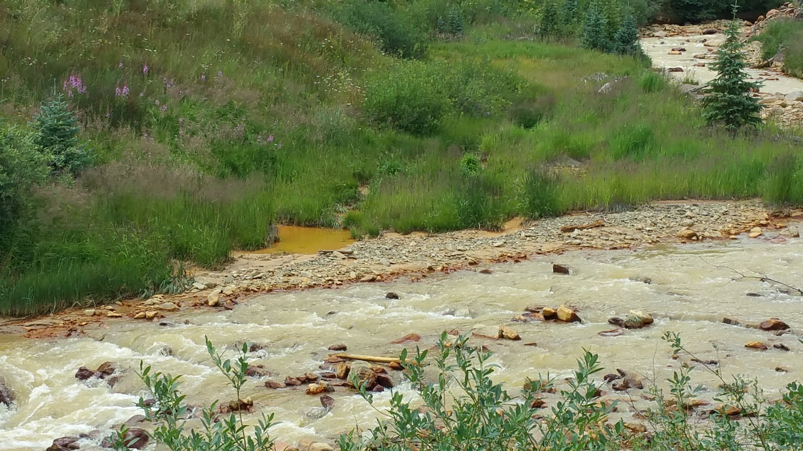
This is the site where the EPA caused a huge mining spill contaminating millions and millions of gallons of water. We went on this a week after the spill and the river downstream wasn't too contaminated but there was a lot of standing water that was opaque and yellow from the flooding when the spill ran downstream.


 This is the spur I took, sorry I don't have any pictures of the loose climb.

This picture is the view from the top of the spur.

From the top of the spur you can look down on the road that you will drive on after you cross Hurricane Pass. Hurricane Pass is just left off the picture. 


We always pick a great lunch spot with a fantastic view!


This is the hardest section of the road.


This is Lake Como, a beautiful little lake. I believe the road below is Poughkepsie Gulch.


Molly was really excited to see the sheep.

This is the spot where I fell in love with the San Juan Mountains when I was a kid. These rolling, green, alpine tundra areas stuck with me that when it was time to find a job I found one out here!


These are just above Animas Fork.