Friday, August 8, 2014

Engineer Pass (part of the Alpine Loop)

Difficulty Rating: 3. (Peter Massey gives this a 4, TrailDamage gives it a 3. The day I traveled it, it was a 3 but it may be worse depending on weather and condition) You definitely need low range for this trail and higher clearance than stock would be nice but not required with careful driving. We followed a stock second genearation Nissan Pathfinder for a while, and I'm sure it didn't have many issues with the difficulty. There is no way my stock Jeep Patriot could handle this road, mostly because of the lack of low range, but the poor clearance would make it difficult as well.

EDIT 2016: The trail was much more torn up for the first part just after leaving the pavement. It is a solid 4 as of 2016.

Location: This starts just north of Ouray, CO and comes out at Lake City. This is part of the popular Alpine Loop.

Trailhead: The West side is 3.3 miles south of Ouray from the turn-off to Box Canyon Falls on the Million Dollar Highway (Highway 550). The East side is at the corner of 1st St and Bluff St in Lake City.

Coordinates for the west side are: 37.988642, -107.649686. Coordinates for the East Side are 38.026923, -107.319492. I changed what coordinate system I am using because I can easily get this format from Google Maps, which is much quicker than getting the coordinates from the gps on my phone like I have been doing.

Engineer Pass was completed in 1877 and was mainly a stagecoach and freight route for the mining camps in the area. You pass many mines and the remaining buildings while traveling on this road. Many of the mines are still open. I didn't explore any of the mines because going on this run was a spur-of-the-moment decision. These mines were not operated for long since it was too expensive and time consuming to transport the ore and equipment.

The scenery on this road is breathtaking. My wife started rolling her eyes because I wanted to stop at every turn and take another picture. This is the reason I moved to Colorado, and this road did not disappoint. The sign at Engineer Pass states the elevation is a modest 12,800 ft in elevation. Before you cross the pass, you are a little higher in elevation and you drive down to get to the pass.

One of the highlights of the road is Oh! Point. There is a turn off 0.4 miles just west of the pass. This is a short road that is less than a quarter mile but ends on top of a knoll that gives you a near 360 degree view of the mountains in the area. This was one of the best views of the San Juan Mountains that I have seen so far, and I recommend taking a few minutes to see it.

This road is part of the Alpine Loop, along with Cinnamon Pass Trail (which I haven't done yet, but it is on my list). You can do both of these trails in one day. Engineer Pass took us about 4.5 hours from start to finish, including a lunch stop. From what I have read, Cinnamon Pass takes about 2 hours and is a little easier. Since we started late, we didn't reach Lake City until about 4:30 in the afternoon, and it would have taken another 4 hours to get back home if we did Cinnamon Pass so we decided to do it another day.

All and all, it was a fun day. And on our way home I convinced my wife to take a "short cut" on the way home across Sapinero Mesa, which in my defense actually cut some time off our 2.5 hour drive home.

Here is the KML.


 This was a fun shelf road at the beginning.


 There must have been a small snow slide during the winter,
now the river cut a hole through it.

 That is Poughkeepsie Gulch road in the background. If you 
want to travel up the gulch, you start from Engineer Pass. It
is a fun Jeep Road that requires a fairly modified vehicle.


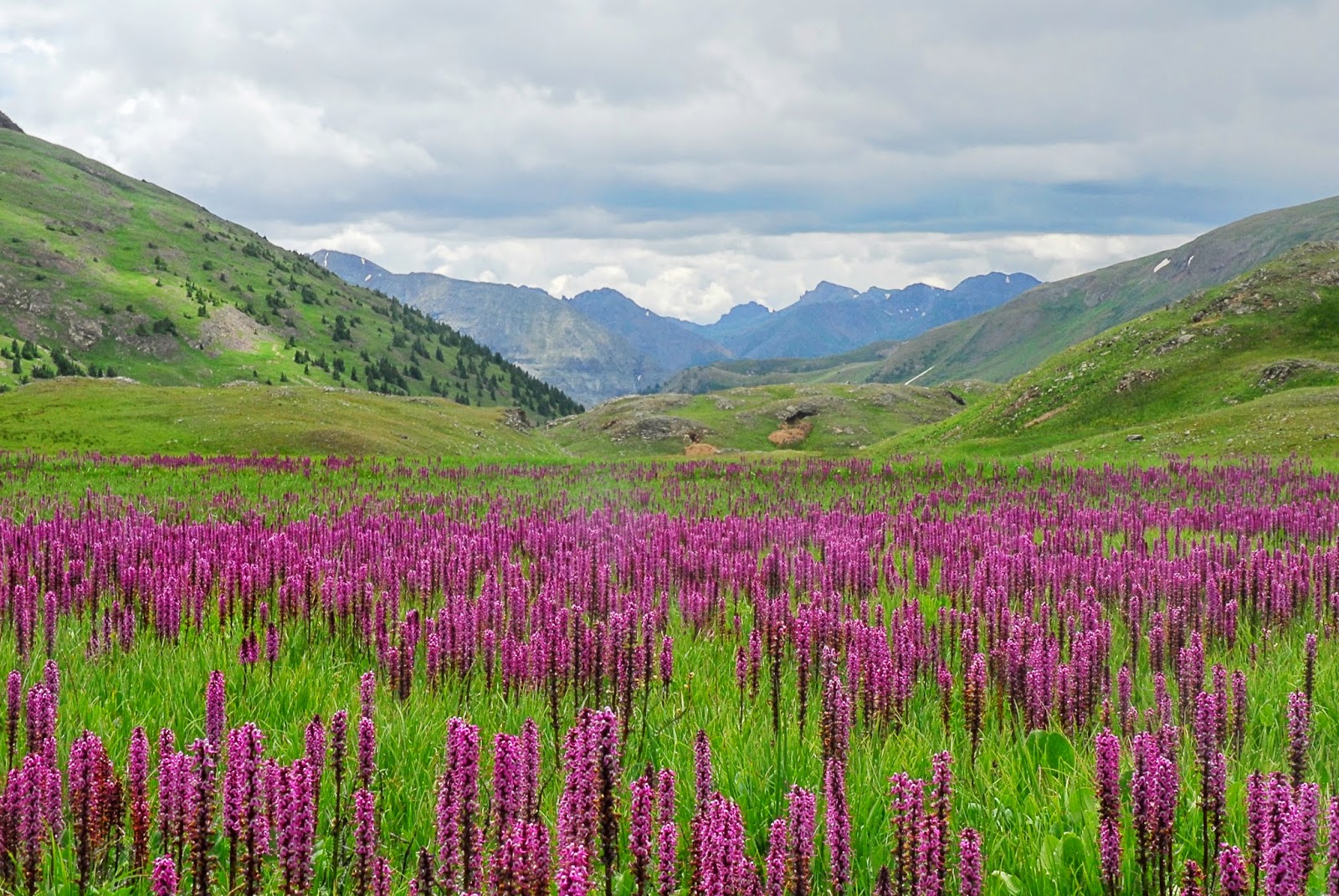
 This was a fun marshy meadow with these pretty flowers.
This was only a few miles before you reach the pass.


 12,800 ft high!


 We sure know how to pick a good lunch spot!


This is a panoramic shot from Oh! Point taken with 
Tiona's phone. Zoom in so you can get an idea
of the view you have. It still doesn't do it justice.


Sapinero Mesa

Difficulty Rating: 1. This is an easy, graded road. About half-way through it has a speed limit sign of 35 mph. 35 mph, however, seems painstakingly slow and 45-55 mph feels about right through most of it (not saying that I was speeding...).

Location: Between Blue Mesa Reservoir and Highway 149 to Lake City.

Trailhead: The north side starts on Highway 50 43.2 miles east from the junction of Highways 550 and 50 in Montrose or 21.7 miles west from the junction of Highways 50 and 135 in Gunnison. The south end starts 21.1 miles south on 149 from the junction of Highways 50 and 149 or 23.8 miles north of Lake City.

Coordinates are 38°27.89 N, 107°15.79 W at the north end near Blue Mesa Reservoir side, and 38°16.84 N,  107°10.58 W at the south end.

This is a quick, short road. It took us less than 30 minutes to drive it. The scenery isn't nearly as spectacular as the nearby San Juan Mountains, but it is still fun to get off the pavement for a nice drive. There is little vegetation through most of the drive as you can see below, which lets you see for miles and miles during most of the road.

For me, the main reason I will drive this road again is for the shortcut. If you are traveling from the Montrose area to Lake City, this will cut off about 18 miles. If you stay on pavement and drive the listed speed limit, it is 33.5 miles from the start of this road to the end. If you take the Sapinero Mesa road, it is 15.4 miles. If you drive the speed limit on pavement (65 through most of it) as well as on the dirt road (35 mph) you only save 4.5 minutes. However, it is nice to get off the pavement and cut off some miles without loosing any time. I will definitely take this shortcut again if I am traveling to/from Lake City.

Here is the GPX and KML files of our trip.


 Overlooking the Blue Mesa Reservoir

These are the Dillon Pinnacles that you
can see across the Blue Mesa Reservoir

Thursday, July 17, 2014

Lands End Road and Grand Mesa

Difficulty Rating: 1. The Lands End Road is a graded road with washboards. A passenger car can easily travel the entire length from the valley to the top of the mesa. From the top at the Lands End Observatory, a passenger car should be able to travel south along the rim to the highway that crosses over Grand Mesa with no difficulties. We went north along dirt roads that would be the upper limit of a passenger car. My wife was driving our Jeep Patriot and hit her undercarriage on a deep rut, but otherwise no difficulties. It is mainly due to some deep ruts that would make it a little more difficult for a passenger car. No 4-wheel drive is necessary.

Location: Grand Mesa, between Delta and Grand Junction, CO. 

Trail head: 25.5 miles north of Delta, CO (from the Maverick gas station) or 7.5 miles south of Grand Junction from the intersection of highways 50 and 141. GPS Coordinates are 38°56.14N 108°23.79W.

Lands End Road starts at the above coordinates. The road is marked with a sign for the turn-off for "National Forest Access Grand Mesa Lands End." The first 9 miles are paved until you enter the Grand Mesa National Forest. The road from there to the top is a well maintained road with some washboards. It starts at about 5200 feet in elevation and ends at about 10,500 when you reach Higway 65 on the top of Grand Mesa. 

The road starts in the desert valley with sparse sagebrush, then it transitions to a cedar forest, then scrub oak and some scattered pinion pines, then to aspen trees, then to pine trees. There are multiple views of the Uncompahgre Plateau. When you approach the top you go through some large rock fields along the base of a cliff. We also saw a small waterfall going down one of the cliffs that was neat to see. 

This road was built by the Civilian Conservation Corps (CCC) between June 1933 and May 1934 and the workers were paid one dollar a day. The sign at the top stated that they built the whole road "blasting and all, without injuries." I guess times were different, not many people would do that job for $10 an hour!

When you reach the top you can stop at the Lands End Observatory. It was build by the Forest Sevice and the Works Progress Administration in 1936-37. It is situated near the edge of Grand Mesa where you can look down on Grand Junction, the Uncompahgre Plateau, and the valley to the south. On a clear day you can see as far as the La Sal mountains to the west in Utah. If you look to the north you will be looking down on the Book Cliffs. I'm used to seeing the Book Cliffs from the I-70, so that was a nice change of perspective.  

We turned north from the observatory to stay on the dirt road. This road wasn't quite as well maintained and had deeper ruts, but no 4-wheel drive was needed. Higher clearance was nice so I didn't have to worry about going over the ruts, but a lower clearance vehicle could have passed through with care. The road we followed came out just 10 miles southeast of Powderhorn Ski Resort. 

The top of Grand Mesa is gorgeous. It is filled with multiple fields with wild flowers surrounded by pine trees and hundreds of lakes. These lakes seem to be popular to the fishermen in the area. Wikipedia states it has over 300 lakes and reservoirs, and reaches an elevation of just under 11,000 feet. Shortly after we got onto Highway 65, there was a sign saying the elevation was 10,839 ft. The elevation made it pleasant. It was about 70 degrees on top of the mesa, while down in the valley it was over 90 degrees. 

We still had time in our day so we didn't drive home down Highway 65. We turned in at the Grand Mesa Visitor Center and followed the easy graded roads that access many of the lakes. We were greeted with more green fields, wild flowers, pine trees, and mountain lakes. It was a pleasant drive on well maintained roads with some great views. We joined once again with Highway 65 in Cedaredge and made our way back home to Delta.

During our trip there were multiple forest roads branching off that looked like fun and would actually require 4-wheel drive. Too bad we didn't have time to go exploring...

Here are the GPX and KML files for the Lands End Road. Here are the GPX and KML for the road we took along the lakes on the top of Grand Mesa. 

 A nice view of the Uncompahgre Plateau.

 Another nice view of the Uncompahgre Plateau.

 The rock fields you go through as you near the top.


 This is the view from the Lands End Observatory.

 If you look closely, the La Sal Mountains are on
the right at the horizon. Also, you can see the
Lands End Road snaking up the mountain.

 View of Grand Junction. You can see the Book Cliffs
just to the right of midline.

 The La Sal Mountains just visible in the distance,
about 70 miles away.

 This is the Lands End Observatory. It is boarded up,
so we couldn't see the inside. 

 This is the view from on top of Grand Mesa

 One of many meadows and tress on top of Grand Mesa.


 This is where we stopped for lunch. It was a nice 
shady area under the trees by the lake. 


 This is one of the lakes by the visitor's center.


Sunday, July 13, 2014

Owl Creek Pass (Difficulty 1)

Difficulty Rating: 1. The first 15 miles I followed a Buick sedan, so this is passable in a car in dry conditions. Depending on recent weather, however, the rating may go up to a 2 if there are a lot of ruts. The south end on the trip had about 6 inch deep ruts. A passenger car still could have gotten around them, but it would have required some careful driving to not bottom out in a small car. I never shifted my Cherokee into 4-wheel drive during the trip.

Location: Just east of Montrose, CO

Trailhead: 22 miles east of Montrose, CO. There is a sign pointing to Cimarron Rd, which is the road you follow. Coordinates are 38°24.87'N 107°31.61'W.

We ended on County Road 8 at 38°13.40N 107°43.61W on highway 550, just north of Ridgeway. We came out at that road because it was closer to home since we live north of Montrose. You can end at Ridgeway on County Road 10 at 38°10.43N 107°44.52W. The benefit of going through County Road 10 is that it is marked with sign for Owl Creek Pass and Silver Jack Reservoir if you are starting from the Ridgeway side.

Description: Easy, graded dirt road. There were moderate washboards in a few areas, but generally a smooth road. According to the visitor information on the website for Montrose, this road was originally a cattle-drive trail from 1885. Initially the scenery seemed to be rolling hills and scrub brush, but later it turned into pine trees and aspen tress. The features that most stick out are the jagged peaks and spires of Cimarron Ridge, Courthouse Mountain, and Chimney Rock. Every time I drove down Highway 550 toward the San Juan Mountains, I always admired the jagged skyline that Cimarron Ridge forms, and I was pleased to have a much closer look. There are numerous jagged cliffs and spires that make the trip worthwhile. As an added bonus, you get a few great views of the San Juan Mountains in the distance.

Expect to see a lot of traffic on the road. There are many campgrounds and access to numerous roads in the area. This is also the access to Silver Jack Reservior, which is a nice lake in the mountains. Supposedly it has good fishing, but I wouldn't know too much about that.

All in all, it was a fun day.

Here are the GPX and KML files. The GPX file is incomplete (only the red portion on the map below). I am using my phone for the GPS and it died right at the beginning. I didn't realize it wasn't working until the red portion started (it recorded the first 200 yards, which I didn't include). I included the rest of the trip on the KML file with google maps, which should have both portions of the track.


Wednesday, June 25, 2014

My New Jeep

I have decided that my little Jeep Patriot wouldn't be adequate to take off road. My Patriot isn't the trail rated version so it doesn't have the lower gearing, it has no low range, it has poor clearance, and a small engine. You combine all of those things it can't go up a hill with a 4 inch ledge without going 25 mph. I love my Patriot, but it is a car, not an off-road vehicle. I have no regrets buying my Patriot, in fact I would buy it again. However, now that I am moving to Colorado in 5 days, it was time to buy a different vehicle.

I have been looking at 4-wheel drive vehicles for about a year. I have considered many vehicles, such as the old CJ, the Wrangler (TJ and JK), the old Cherokee, the new Cherokee, the Grand Cherokee, the Land Rover Discovery as well as other Land Rovers, the X-Terra, Hummers (H2 or H3), the Toyota Tacoma TRD edition, and many others. It took me a year of looking to come up with a decision.

If I had my choice, I think I would have chosen an old CJ-7. There is just something about those vehicles that just calls to me. I have always loved them. I know the leaf springs don't have the same flex as the new coil systems, but I still dream of getting one. I looked long and hard at CJ-7's, but then my wife so lovingly reminded me that I have a daughter that is less than 2 years old and we will have another kid in the not-so-distant future. She said a vehicle with no AC and only 2 doors is probably not the best idea with little kids. I grudgingly agreed. Maybe I shed a tear, but I will never admit it. Even though I wanted a CJ-7, I couldn't argue with her. She was right.

I narrowed my search to 4-door vehicles with AC. Ideally, I would have liked a Wrangler, the 4-door Rubicon. My pocket book, on the other hand, didn't like it. I decided on buying the XJ. I found one for $4,500, AC works well, and only mild rust. It called to me. It didn't call as loudly as the CJ-7 calls, but the XJ looked and felt like a "real jeep." I don't know how to describe it, but it felt like something that should be taken off road. I feel like the XJ was yearning to be in the mountains, not on pavement. I was drawn to it almost as much as I am drawn to a CJ-7. As an added bonus, it fit my wife's requirements. I am now the proud owner of a real 4-wheel drive vehicle. I can actually go exploring the roads of Colorado and Utah that are more than a gravel road. I think the Cherokee will be a temporary vehicle (maybe 5 years) until I can afford a 4-door JK Rubicon for my wife, but for now it will be my baby. And since the Jeep is 14 years old, I won't feel bad if I beat it into the ground and destroy it. I'm excited to try it out and be able to post my trail-runs on this site!

I bought this Jeep while visiting my in-laws in Utah last week. The next day I started parking the Jeep with a tire on a curb and other similar positions. I really needed to take it off road. My trip to Utah was short, and I only had 2 free hours that didn't have something scheduled. After much begging, I finally convinced my wife to go on a drive. We went up American Fork Canyon, a canyon I know well from my childhood. Since I only had 2 hours free, I couldn't go far. I did, however, spend about an hour on dirt roads and even got to put my tires on some rocks and try out the low range. Yes, my new love affair with the Jeep has begun. At least my wife can be a part of the affair, and she is slowly starting to fall for the Jeep.

While I was out, I did realize that I need to buy some quick disconnects for the sway bars. That will probably be my Christmas Present this year. As you can see, I had no flex in the front axle. I actually had more flex in the rear leaf springs than the front coil springs! Oh-well, the money pit that is called a Jeep has already started.

Here are a few pictures of my new Jeep.