Wednesday, March 29, 2023

Bobby's Hole (Devil's Lane)

Rating: 5 - 7

Bobby's Hole is a 5-8, but the rating is quite variable depending on erosion. If there have been some recent large storms and no maintenance, the road could be impassable to most, if not all vehicles. 

Location:

Near the Needles District of Canyonlands National Park.

IMPORTANT: Beef Basin and Bobby's Hole do not require a permit. However, if you plan to continue past Bobby's Hole to Elephant Hill as we did, you need to have a permit for Elephant Hill. You can obtain through the National Perk service. 

Trailhead:

The eastern part starts at Bridger Jack Road, located at 38°05'01.3"N 109°34'06.3"W (38.083698, -109.568416). The turn off to this dirt road is 7.9 miles northwest on UT-211 towards Canyonlands. 

The western ends starts at 38°08'27.3"N 109°52'04.8"W (38.140910, -109.868012). This is 0.5 miles west of Devil's Kitchen Campground on the Elephant Hill loop. 

Description:

I have heard several people talk about Beef Basin and Bobby's Hole as two separate trails. The reason is that Beef Basin is accessible by most high clearance vehicles and makes a great in-and-out day trip. Bobby's Hole has a higher rating, so it attracts a different subset of off-road enthusiasts. If you aren't interested in a difficult trail or you don't have a modified vehicle, I recommend that you explore Beef Basin and not do Bobby's Hole. 

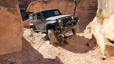
The road through Beef Basin turns into Bobby's Hole. Bobby's Hole is a washed out descent (or climb if you are coming from the Elephant Hill side). This can get fairly eroded and I have seen videos of this climb being quite a challenge for a stock vehicle. The erosion is bad enough they have put in some type of erosion barriers along the hill. 

When we did the trail, we went down Bobby's Hole. I would rate going down a 5 when we did it. It was something I would definitely take my mildly lifted 2015 4Runner with 33" tires down. I would have to choose my line carefully and watch my rear bumper, but it wouldn't have been too difficult to navigate down. I would hesitate taking my 4Runner up Bobby's Hole as the difficulty is at the upper limits of only having a rear locker. I took my 2000 Jeep Cherokee on this trip because of Bobby's Hole. I have front and rear lockers, a mild lift, and 33" tires on the Cherokee. Going down was simple and I only had to pick my line in 1-2 spots. It would be a fun climb in the Cherokee, but we didn't have time. A 4-door wrangler with 35" tires and front and rear lockers would have no issues.

As I have previously stated, erosion is an issue on the Bobby's Hole Dugway. They have put plastic retention matting on the hill to help, however it still can be impassable. I have seen pictures where there were 6 foot deep ruts going down the center of the road. I saw one picture of a guy standing in the rut and the top was higher than his head. From the pictures I would have rated the climb as a 9-10, something that only dedicated rock crawling rigs would attempt.

After Bobby's Hole there is another obstacle called SOB hill. This is a fun, loose climb where you have to do a tight right hand turn between two slick rock walls. This requires either a mutli-point turn (many do a 5-7 point turn) OR pulling up past the turn then backing through the turn. There is a 3rd option of turning sharp and going over a large boulder/ledge. 

When we did SOB hill, the lifted 4-door JK on 35" tires went over the boulder. My cousin in the 100 series land cruiser and me in the XJ opted to do the multi-point turn. Once we went through, we decided the easiest method is backing up through the last part, but this didn't even cross our mind. This obstacle is probably rated a 5. 

The scenery between Bobby's Hole Dugway and Elephant Hill is enjoyable. There are multiple sandstone cliffs and ridges typical for the Needles District. 

Beef Basin and Bobby's Hole can be done in a day trip, but expect a long day. We did it in two days, which was MUCH more enjoyable. We camped at the Devil's Kitchen Campground, which I also highly recommend. This is a neat campground where you camp in varied caverns eroded into the slick rock. 

Another benefit of doing this over a few days is that we also did an optional spur, Davis Canyon. Davis Canyon parallels the Bridger Jack Road and is rated a 3-4. This is a slower, but less travelled road that can be taken if you want to minimize driving on a 1 rated gravel road. 

Here is the KML of Beef Basin, Davis Canyon, and Bobby's Hole

This is Bobby's Hole. Sadly we didn't get many pictures because
there was a group waiting at the bottom to go up.

This and the next several pictures are SOB hill. 


The kids loved playing along the rocks, cracks, and 
caverns of the Devil's Kitchen Campground


Typical night. My youngest daughter falls fast asleep
while the oldest doesn't sleep

It was a long day, okay?

Friday, March 24, 2023

Old Lime Creek Road (Rating 2)

 Rating: 2

This is an easy road and 4wd is not required. The road can be rocky at times that prevent a typical passenger car, but a slightly higher clearance vehicle should have no problems.

Location: near Purgatory Ski Resort

Trailhead:

The southern end of the road is at 37°39'30.4"N 107°48'33.5"W (37.658446, -107.809294). This is located 2.4 miles north of the Purgatory Entrance on Highway 550. 

The northern end is at 37°43'15.9"N 107°45'00.8"W (37.721091, -107.750212). This is located 5.9 miles south of the Molas Lake Campground turnoff on Highway 550.

Description:

Old Lime Creek Road is a short road that parallels highway 550. It is located between Purgatory and Silverton. This is a great alternative to the pavement when you are travelling along 550.

This isn't a "destination" type road, meaning I don't recommend coming down to the area to just do this road. Old Lime Creek Road, however, is a perfect addition when you are already in the area. People often do this road when they are exploring other roads in the area. We did this road the same day we did Bolam Pass

Old Lime Creek Road follows a slightly different route than 550. Along the southern portion of the road you go through trees and along ponds that are often covered with lily pads. The northern part of the road is a narrow shelf road with great views. There are places where the shelf road is narrow enough that passing isn't possible. When you are in the shelf road area, remember where the closest wide spot is located. You may have to back up to the nearest pullout to allow the oncoming vehicle to pass.

One of the fun parts of the road is that this used to be the main highway between Durango and Silverton, before the current road was built. There are sections of the shelf road that have the man-made stone walls as a barrier between drivers and the cliff.

Here are the GPX and KML files.


Bolam Pass

 Rating: 2

We did the pass immediately after they had done maintenance on the road. At that time 4WD was not required.

Location: Between Rico, CO and Purgatory Ski Resort.

Trailhead

The western side of the road starts just north of Rico, CO. The GPS coordinates are 37°46'08.4"N 107°59'18.0"W (37.768994, -107.988321). The road is 6.6 miles north of the gas station in Rico on highway 145. It is located 5.9 miles south of Lizard Head Pass. The road is on the east side of the highway. 

The eastern side of the road is near the entrance to Purgatory Resort. You turn into the main entrance of Purgatory Resort and follow Purgatory Blvd for 0.4 miles. The road is on the right. GPS coordinates are 37°37'59.2"N 107°48'41.6"W (37.633121, -107.811557).

Description:

Watch a YouTube video of our trip!

Bolam Pass is a gem, and I hesitate sharing it because I don't want it to become popular like the Alpine Loop. Having said that, I suspect it won't be as crowded because you don't need 4-wheel drive and it is further away from other popular trails. However, if you are in the area, I highly recommend this trail. To be honest, it is currently my favorite road in the San Juan Mountains. The reason? There are less people and the scenery is spectacular. It is a relaxing road to get up into the mountains and enjoy the views.

The road is a simple, well maintained forest road. When we went on it they were grading the road. They didn't put down much road surface, so the road is still a typical dirt base and not a gravel road. This has the potential to get a little rough depending on when it was last maintained. 

I have heard reports that it was difficult trail, but then I saw reports that 4-wheel drive wasn't required. One example is when we stopped at the Cayton Campground when we started the trail. This is a great campground and I wanted to show my cousin the campground so we can stay there in the future. We stopped and talked with the camp host. When we told him we were doing Bolam pass, he looked at my cousin's Lexus GX470 and said his vehicle would not be able to make it. He commented that the road was too rough and he didn't have enough clearance. We thanked him for his advice, but knew my cousin has done much more technical trails in his GX470. We did shift into low range during the trip, but that was purely for gearing and to use less brakes on the way down the Purgatory side. We did not require 4 wheel drive and only mildly high clearance was needed that day. Honestly, a Subaru Outback would have been fine.

The scenery is spectacular and doesn't disappoint. There are expansive vistas and forests. The mountains are impressive. It is exactly what a high mountain pass in the San Juan Mountains should offer.

We didn't see many people, considering the area and the time of year. We probably saw only 10 vehicles all day until we got close to Purgatory. The last few miles as we approached Purgatory had plenty of vehicles, but up near the pass the number of vehicles were sparse. 

There are several roads in the area. Bolam Pass is county road 578.  Most of the turns are obvious as county road 578 is typically the main road. However, if you start from the Purgatory Side, there is a turn to the right at 37.656694, -107.932575 where the main road goes left and 578 goes right. This is an easy turn to miss if you start from Purgatory. 

Here is the KML and GPX files for the road.